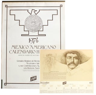
1974 Mexico~Americano Calendario Historico: Mexican American Historical Calendar... [Cover title].
Milwaukee, Wisconsin: Jos. Schlitz Brewing Co., 1973. 19¼” x 14”. Loose leaves printed rectos only held with steel bar at top. Very good: a few light stains and stray ink to cover page; a few minor creases. This is a wall calendar dedicated to Mexican American history. The full..... More


![Item #4726 [Program for] 22nd Anniversary Celebration. Hering Community Center... [Cover title](https://langdonmanorbooks.cdn.bibliopolis.com/pictures/4726.jpg?width=320&height=427&fit=bounds&auto=webp&v=1704899609)


![Item #7957 [Photo Album Depicting Native Americans at the Rosebud Indian Agency]. Anderson, ohn,...](https://langdonmanorbooks.cdn.bibliopolis.com/pictures/7957.jpg?width=320&height=427&fit=bounds&auto=webp&v=1709571131)

![Item #4263 The Samuel Huston Bulletin [Vol. 4, No. 2 (April 22, 1933)]. Karl Downs](https://langdonmanorbooks.cdn.bibliopolis.com/pictures/4263.jpg?width=320&height=427&fit=bounds&auto=webp&v=1701633135)

