![Item #4004 Map Showing Houston & Texas Central System of Railroads. [Front Panel Title: See Texas Via the H And TC. It Takes You Through the Best Farming Country in the State.]](https://langdonmanorbooks.cdn.bibliopolis.com/pictures/4004.jpg?width=768&height=1000&fit=bounds&auto=webp&v=1639415461)
![Map Showing Houston & Texas Central System of Railroads. [Front Panel Title: See Texas Via the H And TC. It Takes You Through the Best Farming Country in the State.]](https://langdonmanorbooks.cdn.bibliopolis.com/pictures/4004_2.jpg?auto=webp&v=1614711062)
![Map Showing Houston & Texas Central System of Railroads. [Front Panel Title: See Texas Via the H And TC. It Takes You Through the Best Farming Country in the State.]](https://langdonmanorbooks.cdn.bibliopolis.com/pictures/4004_3.jpg?auto=webp&v=1639415461)
![Map Showing Houston & Texas Central System of Railroads. [Front Panel Title: See Texas Via the H And TC. It Takes You Through the Best Farming Country in the State.]](https://langdonmanorbooks.cdn.bibliopolis.com/pictures/4004_5.jpg?auto=webp&v=1639415461)
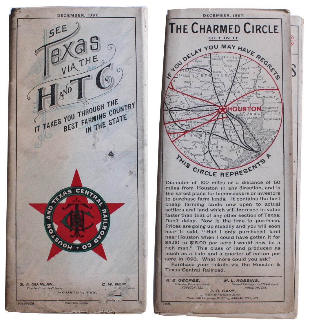
Map Showing Houston & Texas Central System of Railroads. [Front Panel Title: See Texas Via the H And TC. It Takes You Through the Best Farming Country in the State.]
Chicago: Poole Bros. Map Engravers, 1897. 8¾” x 4” folded; opens to 17½” x 34¾”; Map of the United States: 16½” x 30½”; County Map of Texas: 11¼” x 11¼”. Very good: moderate staining and a few small nibble holes to outer panels costing a couple of characters in panels, and a tiny portion of the main map; a few small separations at intersections.
This is a rare timetable/land promotional issued by the Houston and Texas Central System of Railroads (“HTC”) with three maps. Chartered in 1848, the line was a predecessor of the Union Pacific Railroad and construction began in 1856. It ultimately stretched 872 miles from Houston to Dallas and Denison with branches to Austin and Waco.
The map of the United States is printed in four colors with Texas showing the HTC rail lines in a thick black. There are two illustrated vignettes at bottom, one showing cattle grazing, the other portraying African Americans picking cotton. To the left of the image of cotton picking is a panel of text that touts the growth of the cotton crop since 1887 as well as a recommendation for land agents in southern Texas. The inset county map of Texas shows the HTC rail stops in far more detail. A third, smaller circular inset map on the rear outer panel provides a detailed 100 mile radius around Houston.
Three text panels contain timetables as of August 1897. Four panels advertise specific routes including the Lone Star Special and the Buffet Sleeper Line. Two more contain land promotionals including one from a San Antonio land agent for the HTC, C.C. Gibbs, who ultimately became Texas Land Commissioner.
OCLC locates one copy of the 1895 edition, an imperfect copy of the 1898 edition, and no copies of the edition on offer.
This item is offered by Langdon Manor Books, LLC, antiquarian booksellers. We package our items carefully, ship daily, and have a no hassle returns policy--your satisfaction is guaranteed. We are members of the Antiquarian Booksellers' Association of America (ABAA), the International League of Antiquarian Booksllers (ILAB) and the Independent Online Booksellers Association (IOBA) and adhere to their rules of ethics. Very good. Item #4004
Price: $950.00