![Item #7342 [Three Pictorial Maps of Los Angeles]. Cathy Pavia.](https://langdonmanorbooks.cdn.bibliopolis.com/pictures/7342.jpg?width=768&height=1000&fit=bounds&auto=webp&v=1680291721)
![[Three Pictorial Maps of Los Angeles].](https://langdonmanorbooks.cdn.bibliopolis.com/pictures/7342_2.jpg?auto=webp&v=1680291681)
[Three Pictorial Maps of Los Angeles].
Los Angeles, California: Los Angeles Times, 1980. Three posters, each measuring 18” x 23”. Very good: one tiny tear to edge of one map, light foxing in the margin of another; else minimal wear and light creasing to edges.
This is a set of three pictorial maps commissioned for the Los Angeles Bicentennial celebration and originally printed in the Los Angeles Times' Home magazine in 1980. They depict 300 years of Los Angeles area history, though the final hundred had yet to occur. The artist, Cathy Pavia, is a longtime art instructor and freelance illustrator for advertising and magazines. She also created the art for several books, including the Cathy and Company children's book series and Joey Green's The Zen of Oz: Ten Spiritual Lessons from Over the Rainbow.
Each map has a key with between 22 and 38 highlighted areas, with text corresponding to each number along the bottom. The map entitled “The first hundred years, 1781-1881” stretches from Shoo Fly Pier, Santa Monica in the west to “El Monte, first American settlement, 1852” in the east. It shows the San Gabriel mountains to the north, including where the first gold in Southern California was found, “under onions,” in 1842, and extends to present-day Long Beach in the south. Geographical landmarks are identified in their native Spanish, and the map focuses on flooding as well as railroad construction. It also shows us locations for “Yang Na, the first Indian village,” “the first sports arena: a bullring,” and “Camel Express founded at Drum Barracks.”
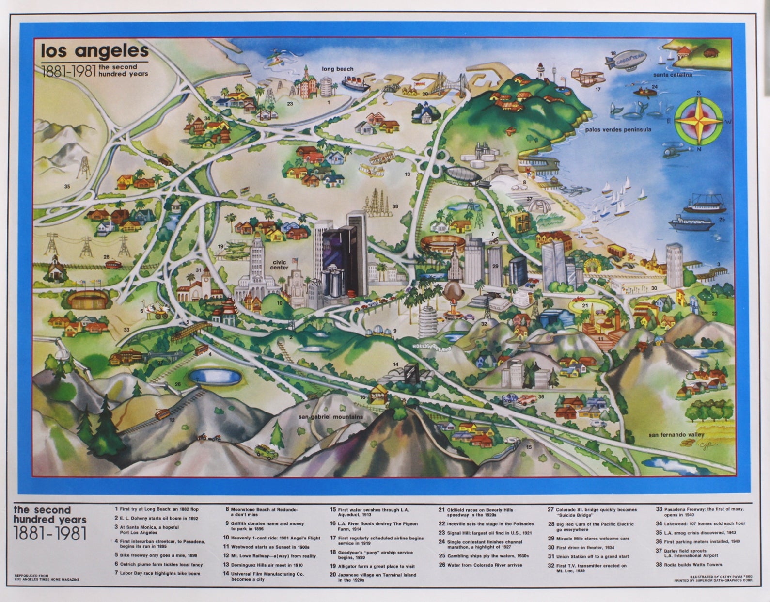
The second map shows the same swath of sea and land but a much updated cityscape for “the second hundred years, 1881-1981.” It reveals “Union Station off to a grand start” and, “At Santa Monica, a hopeful Port Los Angeles.” Important firsts are indicated, including “First interurban streetcar, to Pasadena, begins its run in 1885,” “First parking meters installed, 1949” and “First drive-in theater, 1934.” We see the Hollywoodland sign and the nearby site where the first television transmitter was erected in 1939. The map also casually points out a location for “L.A. smog crisis discovered, 1943.”
“The next hundred years, 1981-2081” is a staunchly hopeful map of the same region, predicting “Centers to replace megalopolis sprawl,” “Rapid transit connects centers,” “Elevated pedways will unsnarl cars and people” and “More greenery, less blacktop for L.A. streets.” It also pushes for a return to simpler days with a “Horse trail through the city center.”
A fantastic group of illustrated maps, both history-focused and forward-thinking. None in OCLC; a Google search revealed one possible holding at the Los Angeles Public Library. Very good. Item #7342
Price: $2,000.00