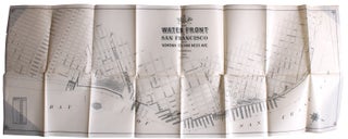
Barker, Ralph. Map of the Waterfront of San Francisco From Sonoma St. to Van Ness Ave.
N.p. N.p., 1908. 15 3/8” x 41¾”. Printed on a coated, waxlike paper. Very good : a couple of tiny separations at intersections, small closed tear at another, 2” vertical separation at far upper left, a couple of small edge chips, some scattered pinpoints of soiling. A scarce map of..... More


![Item #9386 [Manuscript Map of] The World [Caption title.]. Calvin Babbit](https://langdonmanorbooks.cdn.bibliopolis.com/pictures/9386.jpg?width=320&height=427&fit=bounds&auto=webp&v=1778863201)

![Item #9062 Dedicated to the American Indian [Caption Title]. Dicus, arner, arker, Bernice and Dicus](https://langdonmanorbooks.cdn.bibliopolis.com/pictures/9062.jpg?width=320&height=427&fit=bounds&auto=webp&v=1778857649)
![Item #7342 [Three Pictorial Maps of Los Angeles]. Cathy Pavia](https://langdonmanorbooks.cdn.bibliopolis.com/pictures/7342.jpg?width=320&height=427&fit=bounds&auto=webp&v=1680291721)
![Item #9264 Navajo Nation [Caption Title]. W. Sherman, cartographer](https://langdonmanorbooks.cdn.bibliopolis.com/pictures/9264.jpg?width=320&height=427&fit=bounds&auto=webp&v=1775055140)